Saturday, February 19, 2011

Tel Dan


Well, did you have a good lunch? While you were eating I was riding the bus towards the northern border of Israel.  Oh you are so clever! Yes, to a place called Tel Dan. Tel Dan marks the northern frontier of the Kingdom of Israel and double YUP, this city belonged to the Tribe of Dan. 


 This is the Dan River that runs through the Tel Dan Nature Reserve. The Dan River is one of the three water sources of the Jordan River.


The Dan River emanates from this spring. The vegetation around this spring include a forest of oak, oleander and plane trees intertwined with a thick growth of  vegetation.  I just loved this area, the water, the trees, so lush and cool. I could have spent the whole day here for sure!!


Now this is so cool! Do you know how old these walls are? These are Canaanite walls that are, now wait for it, wait for it.... 1800 yrs BC, now that means over 4000 yrs old. So, so cool!  The Tribe of Dan brutally defeated the Canaanite town of Laish and became the town of Dan. This town became a sanctuary filled with Idols.


Our guide, John Lund, is telling us something interesting. I remember some but not all that he had to share. (Guess, I'll just have to go back!) Did you know that Abraham traveled to Dan to rescue his nephew Lot?


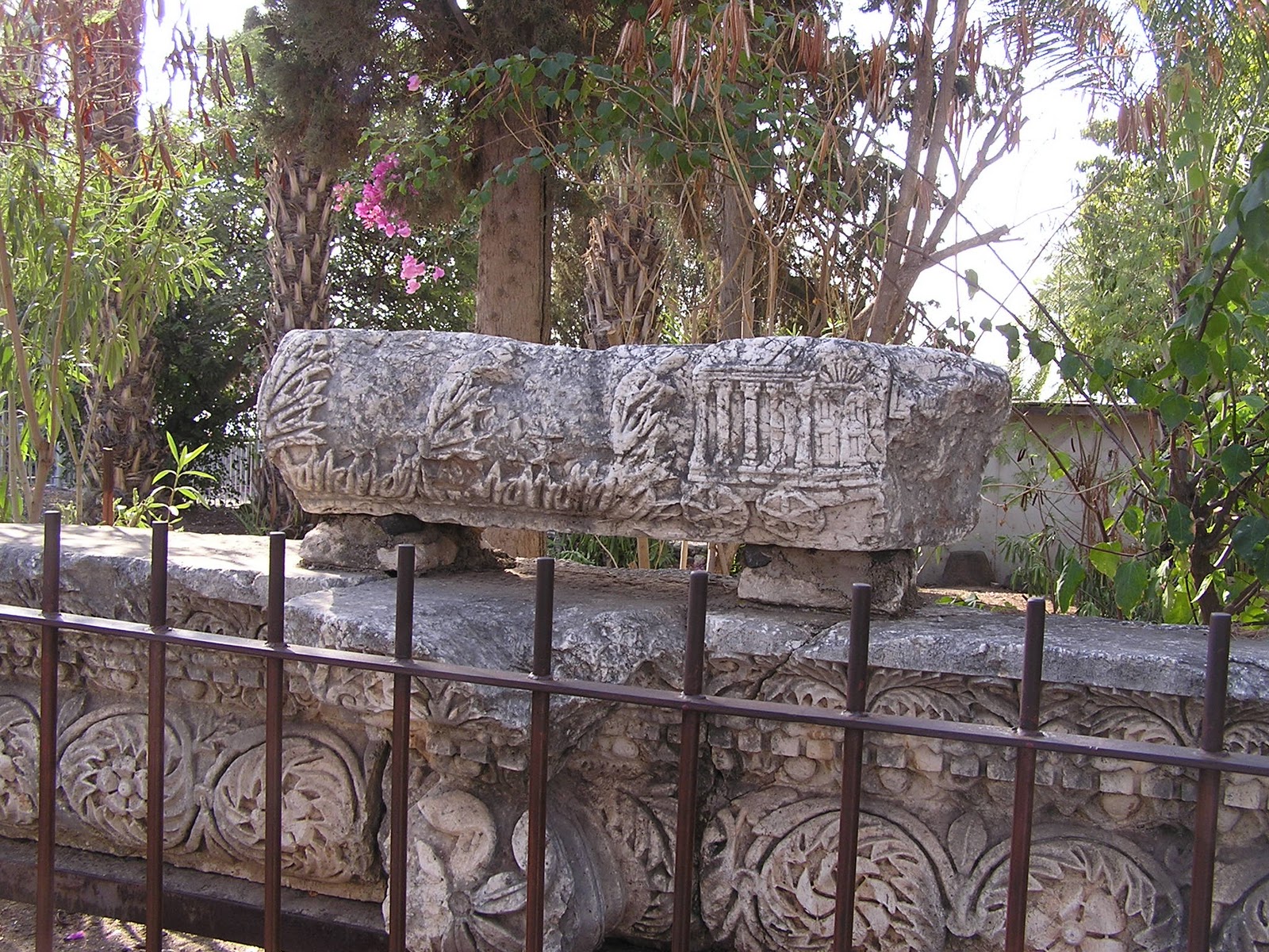
This is what John is pointing at, a bench that could be the type mentioned in the bible as the "Seat of the Elders."  Some of the things I wonder as I look at these old, old, formations is: "What was the workman thinking the day he built this so long ago?" Was his wife mad at him for missing Valentines Day? Was he thrilled with the birth of his first son? Was he waiting for the day to end to visit with the boys? Fun to think about.


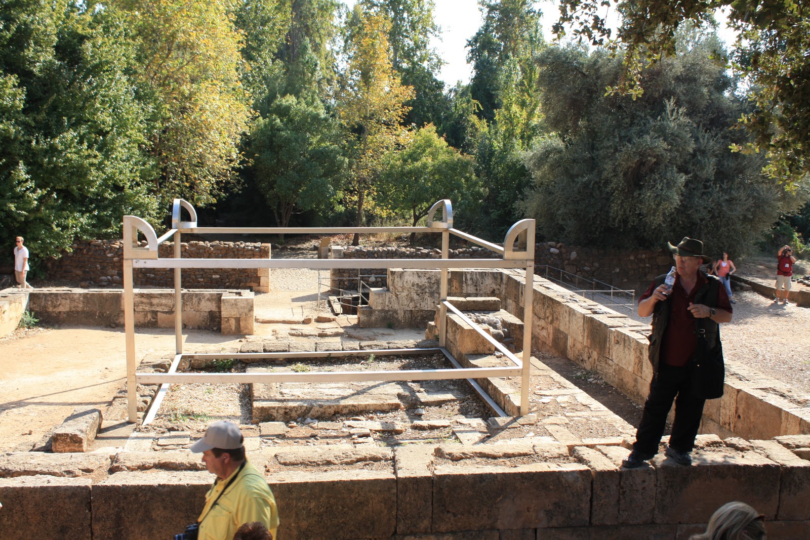
This represents the 4 horned altar. A way to visualize the cult center founded by King Jeroboam of Israel. He also erected two golden calves as Gods in Dan.


Look closely at the brick work on this wall of the temple. The top rocks are "framed" while the bottom ones are hewn rock. The "framed" rocks, or the rocks with the border were built, by King Herod. He wanted to impress the Romans so he built temples and other lavish buildings all over Israel. King Herod the Great, as he was a great builder, but a wicked, wicked King. It's easy to see when King Herod was calling the shots in any of the areas that have nice buildings due to the style of brick used in the building.


The mountain in the distance is Mount Hermon located on the border between Lebanon and Syria. The summit of Mount Hermon is under control of Syria, however, the southern (to the right) and the western (face on) slopes are under control of Israel and is part of the Golan Heights. This mountain is referred to as the "eyes of the nation" in Israel as its elevation makes it Israel's primary strategic early warning system. (We did see a tank in this area).


This is a picture taken to the left of Mount Hermon and is Syria. I think the white buildings on the top have military purposes.


This is even more left (west) of the two previous pictures. This is looking into Lebanon. Our Israeli guide told us that there is a city up there that is half in Israel and half in Lebanon. This is an area that has seen actual conflict.


Interesting tidbits to finish off:

Mount Hermon was part of the division of land for inheritance by the nine tribes.
Half the Tribe of Manassah was given the Mount as part of their inheritance to possess.
Caesarea Philippi, at the southern base of Mount Hermon,(to the right) is where Christ asked his disciples "Whom do men say that I the Son of Man am?"
Christ also reveals the fact that he will go to Jerusalem to die and be resurrected.
Finally, Mount Hermon, is a possible site for the transfiguration of Christ. Where God the Father declares:
"This is my beloved Son, in whom I am well pleased, hear ye Him."

Caesarea Philippi is the final stop for Wednesday 10 November 2010. I hope you enjoyed the day. So much history, so little time.

Sunday, February 13, 2011

Capernaum and The Mount of Beatitudes


We visit the town of Capernaum, the center of Jesus' activities in the Galilee and his home. Who else calls Capernaum home? Well, that would be the apostles Peter, Andrew, James and John, as well as the tax collector Matthew.  Just a note, Capernaum was one of the three cities cursed by Jesus for its lack of faith.


This synagogue, amoung the oldest in the world, was built in the 4th Century. Beneath this building is the foundation of a 1st Century synagogue, perhaps the one mentioned in the Gospels.


This is the ark of the covenant, that was found in this synagogue.
Christ did many miracles in Capernaum. Healed the servant of the centurion, healed the woman with the issue of blood, healed the paralytic lowered through the roof, .......


The House of Peter.  The ruins you see are reported to be the foundations of houses from the time of Jesus and that Octagon building is a new one built over what is believed to be Peter's house. Perhaps this is where Jesus healed Peter's mother-in-law.


This is an olive mill and an olive press dating from Roman times in Capernaum.
Josephus referred to Capernaum as a fertile spring.

Oh my, Dixie Dee!
Capernaum is to my left and this is the north shore of the Sea of Galilee. 
It's fun to think about Jesus walking these shores asking the disciples to:
"Come Follow Me."

This is a view of the Mount of Beatitudes from Capernaum. Look closely you can see a dome shaped building. This site has been the traditional site of the Sermon on the Mount for 1600 years.


This is that dome shaped building, and it is a Roman Catholic Francisan chapel that was built in 1938. The grounds around this building are beautiful and peaceful. This overlooks the Sea of Galilee
This represents an area where the Sermon on the Mount could have taken place. Our guide suggested that the crowd was assembled on the hillside  Jesus was at the bottom of the hill, I always thought of it with Jesus at the top.


This is a view of the Sea of Galilee from the Church on the Mount of Beatititudes. I just loved imagining the apostles and Jesus teaching and living in this area. Fun stuff !


Another view of the Sea of Galilee, I tried to frame the fishing boat by the flowers, but it didn't work out as good as I hoped. C'est la vie!! Thus we come to the afternoon of Wednesday 10 November 2010. There is still more to see today, but I think it's time for lunch and a break!! See ya after we eat!!

Wednesday, February 2, 2011

Arbel Cliff


This is Mount Tabor. We passed by this mountain on our way to our last stop of the day. What is Mount Tabor famous for you ask? Oh I guess I might mention a thing or two. As you may have guessed it is mentioned in the Bible, both Old and New Testament. Tradition links Mount Tabor to the Transfiguration of Jesus.


This mountain is strategically located on the main north-south ancient road and was an important fortress during the First and Second Temple, Greek, Roman and Crusaders times. This is a close up of the Franciscan basilica and other buildings found on the mountain. This mountain has a great view of the Jezreel Valley.


We are at the last stop of the day, The Arbel Cliffs. This is a picture of the caves that are found in the cliffs. I couldn't take one of the caves as we were on top of the cliff and the caves were way down below us. We were standing on the top of the cliff.

These cliffs and caves were used by rebels in ancient times and as a fortress.


This is a view of the area of Galilee to the south. We are 181 m above sea level.


This is a view of the Sea of Galilee. The Sea of Galilee is 200 m below sea level.


This is a view of the north side of the Sea of Galilee. If you look to the far end of the lake near the beaches of the lake is Capernaum.  This is the area of Jesus' Galilean ministry.


This is a view of the area to the left of the above picture.  It is a very fertile area.


This a view of the city of Magdala, famous for its fish and for Mary Magdalene. Beyond the city is the plain of Gennesareth.  I just love to think about Jesus roaming around this area doing his thing and all the other bible characters, this is their stomping grounds. (just a note, that is about a 1000 foot drop, from where I'm standing to the road)


Just a cool view, too bad I didn't think to have Mike take a picture of me standing on those rocks!


Cool picture huh?


Thus we come to the end of Tuesday November 9, 2010. Day 4 of our trip. We sure did see and go a lot of places in one day, oh but there is more to come!! Jerusalem, Calvary, Masada, Mount of Olives, the Dead Sea, .... Some cool stuff coming up.